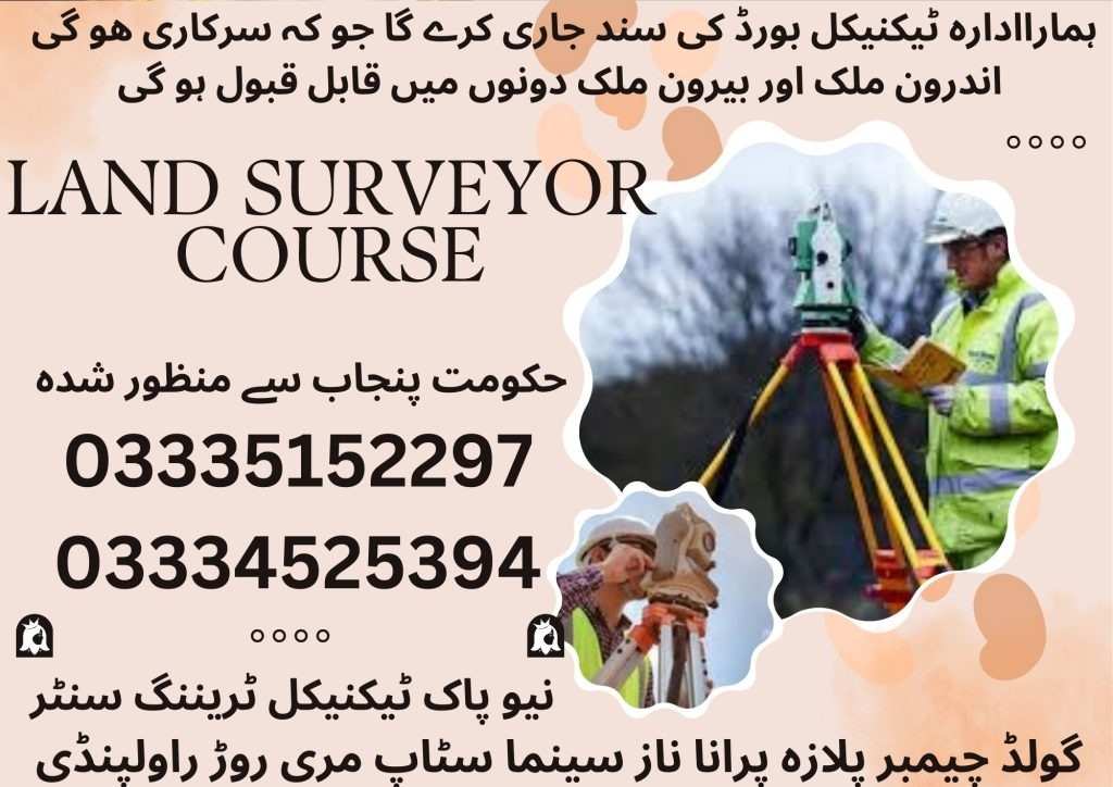
The Land Surveyor Course is designed for individuals seeking a strong foundation in modern surveying techniques and practices. This introductory land survey course introduces essential principles, instruments, and field methods used by professional land surveyors. Whether you’re starting your journey or looking to upgrade your skills, this program offers structured, hands-on Land Surveyor Training aligned with current industry needs. Through practical exposure and technical instruction, students gain the confidence and competence required for a career in surveying.
Course Overview
Our program is divided into two levels: a 6-month Land Survey Certificate course and a comprehensive 1-year survey Diploma in Land Surveying. The first six months focus on core concepts, including linear and angular measurements, levelling, traversing, and drafting, which is ideal for those looking for a solid land survey training course. Students enrolled in the extended diploma continue with advanced topics such as tacheometry, topographical and route surveying, construction layout, and GIS fundamentals. These structured land surveyor classes equip learners with the theoretical and practical skills necessary for a successful career in land surveying.
Course Duration
06 | Months
Surveying Principles & Branches
Surveying Ethics & Professional Conduct
Surveying Instruments Overview
Linear Measurements & Leveling Techniques
Angular Measurements & Traversing
Basic Surveying Practical Techniques
Fieldwork & Data Collection
Drafting & Computer-Aided Surveying (CAS)
01 | Year
Surveying Principles & Branches
Surveying Ethics & Professional Conduct
Surveying Instruments Overview
Linear Measurements & Leveling Techniques
Angular Measurements & Traversing
Basic Surveying Practical Techniques
Fieldwork & Data Collection
Drafting & Computer-Aided Surveying (CAS)
Advanced Leveling Techniques
Tacheometry & Stadia Methods
Topographical Surveying & Total Station Usage
Route Surveying & Curve Calculations
Construction Setting Out & Stakeout Techniques
Land Boundary Demarcation & Legal Procedures
Advanced CAD & Introduction to GIS
Course Outline (6 Months)
Surveying Principles and Equipment
Month 1
History and importance of surveying
Branches of surveying (land, construction, topographical)
Surveying ethics and professional conduct
Overview of surveying instruments
Linear Measurements and Leveling
Month 2
Use of chains, tapes, and arrows
Leveling principles and techniques (differential, profile)
Operation of dumpy and automatic levels
Angular Measurements and Traversing
Month 3
Use of theodolites and compasses
Open and closed traversing methods
Balancing errors and calculation techniques
Basic Surveying Techniques
Month 4
Chain surveying practical
Leveling practical
Traversing practical
Introduction to setting out works for construction
Fieldwork and Data Collection
Month 5
Practical exercises using surveying instruments
Recording measurements and maintaining field books
Basic data processing with surveying software
Drafting and Computer-Aided Surveying (CAS)
Month 6
Introduction to survey symbols and conventions
Manual plan drawing and calculations
Basics of AutoCAD and computer-aided drafting for survey plans
Course Outline (1-Year)
Months 1–6: Essential Land Surveyor Course In Rawalpindi Islamabad
(Same course content as the 6-month program but with more detail, role-plays, software demos, and assessments.)
Advanced Leveling Techniques
Month 7
Differential and trigonometric leveling
Precise elevation measurements over long distances
Advanced Tacheometry Methods
Month 8
Theodolite use with stadia hairs
Calculations for horizontal and vertical distances
Application in topographic surveying
Topographical Surveying
Month 9
Capturing landforms, vegetation, and man-made structures
Contour mapping and terrain modeling
Use of Total Stations in the field
Route Surveying and Alignment Planning
Month 10
Planning and alignment for roads, pipelines, and canals
Curve calculations and setting out routes
Setting Out for Construction Projects
Month 11
Transferring design plans to the site
Layout for foundations, columns, beams, and floors
Construction stakeout and as-built surveys
Boundary Surveying, CAD & GIS
Month 12
Legal procedures for boundary surveys
Boundary marker placement techniques
Advanced CAD for surveying applications
Introduction to Geographic Information Systems (GIS)
Career Opportunities
Land Surveyor
Construction Surveyor
GIS & Mapping Technician
Photogrammetry Technician
Survey CAD Operator
Assistant Survey Engineer
Conclusion
The Land Surveyor Course in Rawalpindi Islamabad, provides a structured path for individuals looking to enter or advance in the surveying field. With both 6-month and 1-year options, the program combines essential theory with hands-on land surveyor training, utilizing modern tools and techniques. Whether you’re pursuing an introductory land surveying course or a full diploma in land surveying, this course equips you with the practical skills, industry exposure, and career support needed to thrive as a professional land surveyor.